Book Now
Short Gosaikunda Trekking near Kathmandu
Gosaikunda Lake View
Way to Lauribina during Gosaikunda Lake Trek

Gosaikunda Lake Trek - 6 Days

Customize Trip
205 reviews in TripAdvisor
86 reviews in Google Reviews
Recommended by 99% of Travelers

Quick Summary

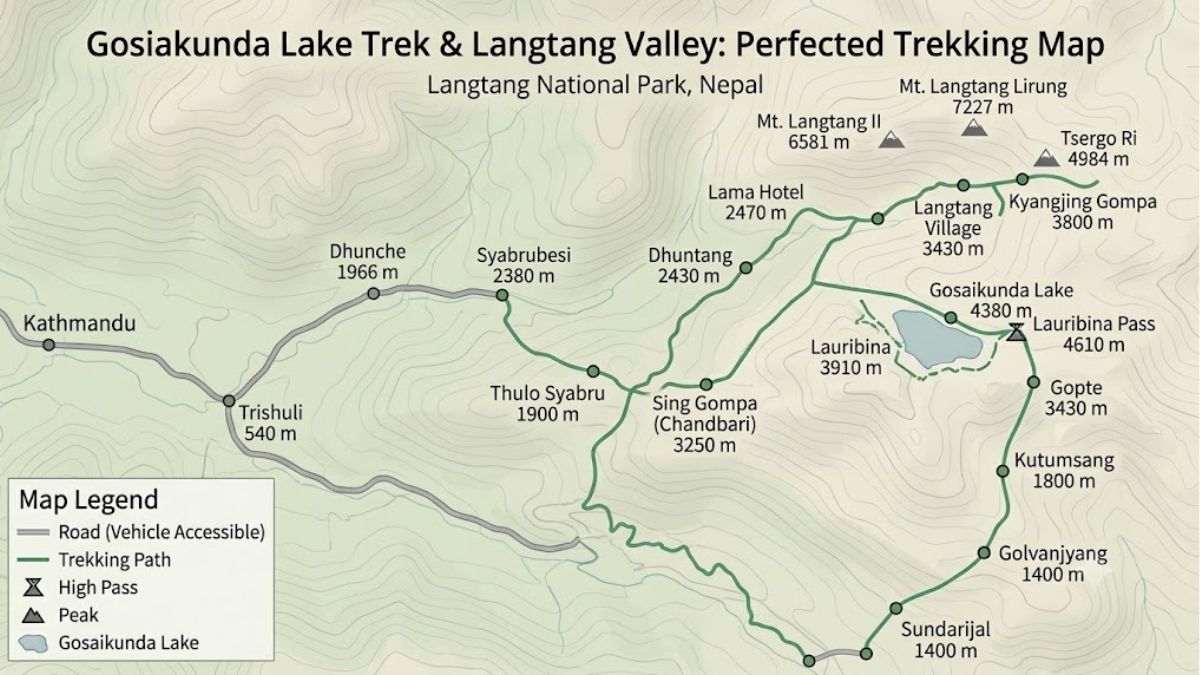
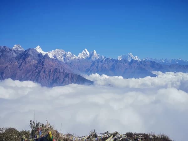
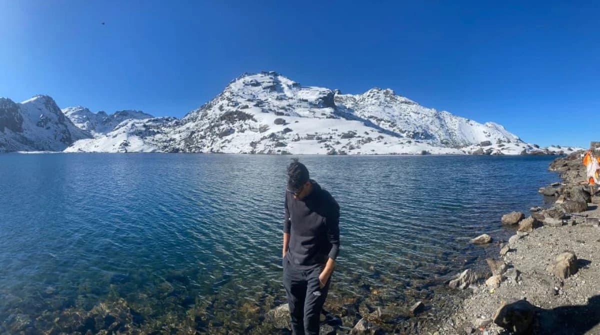
  • The Gosaikunda Lake Trek is a popular 5–7 day high-altitude trek in Nepal's Langtang region reaching 4,380 meters.
  • The trek is located within Langtang National Park and starts from Dhunche after a drive from Kathmandu.
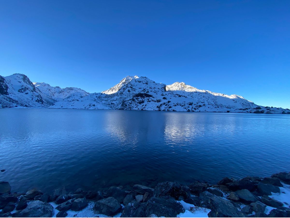
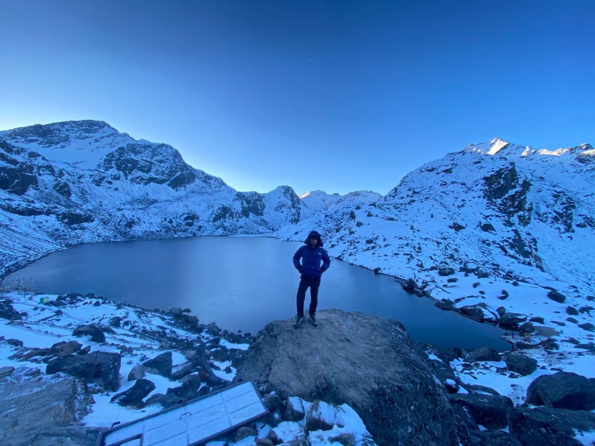
  • Gosaikunda Lake is a sacred pilgrimage site closely associated with Lord Shiva and Hindu mythology.
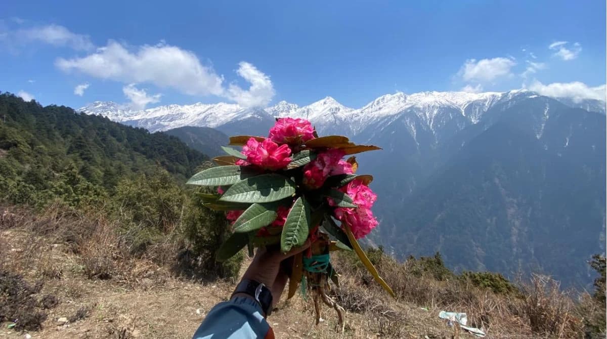
  • The route offers spectacular mountain views, alpine landscapes, rhododendron forests, and sacred glacial lakes.
  • The trek is considered moderately difficult due to steep ascents and high-altitude conditions.
  • Proper acclimatization is important as the trek reaches elevations above 4,000 meters.
  • Spring (March–May) and Autumn (September–November) are the best seasons for the trek.
  • The guide includes detailed information on costs, permits, transportation, accommodation, and food.
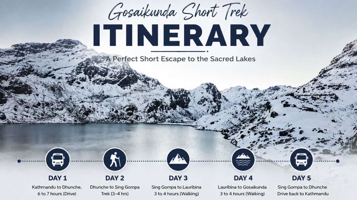
  • A day-by-day itinerary helps trekkers understand walking distances, elevation gain, and route logistics.
  • The trek combines adventure, culture, religion, and Himalayan scenery, making it one of Nepal's most rewarding short treks.
  • An ideal budgeted trek is around $ 300 to $ 400, whereas a standard trek costs around the $ 600, and the luxury trek costs $1000 per person
  • Altitude Sickness and Preventive Measures for the Gosaikunda Trek

Gosaikunda Short Trek itinerary

Duration
5 Days
Trip Grade
Moderate (Intermediate Level)
Maximum Altitude
4,380m (14,370 ft) at Gosaikunda Lake
Group Size
1-12
Starts
Dhunche
Ends
Dhunche
Activities
Trekking
Best Time
Spring and Autumn

Gosaikunda Lake Trek Introduction

The Gosaikunda Lake Trek is one of the popular, moderate-to-challenging trekking routes in Nepal. It is located in the Lantang Region. It is a spectacular high-altitude alpine trek located in Nepal's Langtang National Park, ascending through forests and rugged terrain to reach a cluster of sacred glacial lakes. Gosaikunda Lake is a highly famous pilgrimage site for Hindus and Buddhists, believed to be created by Lord Shiva's trident. It also boasts stunning panoramic views of the Langtang and Ganesh Himalayan ranges.

Gosaikunda Lake during Gosaikunda Lake Trek

What is the Gosaikunda Lake Trek 

The Gosaikunda Lake Trek is one of Nepal’s most revered short trekking routes, offering a brilliant mix of dramatic Himalayan landscapes and profound cultural heritage.

Gosaikunda Lake Trek is situated in the Rasuwa District, just north of the Kathmandu Valley. The entire route unfolds within the protected borders of Langtang National Park, Nepal's first Himalayan national park. Because of this, the trail passes through pristine, protected ecosystems ranging from lush rhododendron forests to rugged alpine terrain.The journey involves a rapid and steady ascent into the high mountains. The main Gosaikunda Lake, the centerpiece of the trek, sits at a breathtaking altitude of 4,380 meters (14,370 feet)

Nepal's most scenic and accessible trekking destinations:  Lantang Region

Gosaikunda is much more than a scenic glacial lake; it is a vital piece of Himalayan mythology. According to ancient texts, Lord Shiva swallowed a world-destroying poison to save the universe. To quench his burning throat, he struck a towering Himalayan glacier with his trident (Trishul), releasing the waters that formed Gosaikunda.

Why Visit Gosaikunda Lake Trek

Gosaikunda Lake View from gosaikunda

If you are looking for an adventure that perfectly balances breathtaking natural landscapes with profound cultural depth, Gosaikunda Lake is an exceptional choice. Here is why this specific trek stands out:

  • A Highly Sacred Alpine Lake: Gosaikunda is not just a body of water; it is a legendary piece of Himalayan mythology. Sitting at 4,380 meters, this stunning, oligotrophic lake remains frozen for about six months of the year before melting into crystal-clear blue waters. It is the centerpiece of a larger network of 108 high-altitude glacial lakes in the surrounding area.
  • Deep Pilgrimage Importance: As the legendary resting place of Lord Shiva, the lake carries immense spiritual weight for both Hindus and Buddhists. During the Janai Purnima festival in August, the quiet trails transform into a vibrant pilgrimage route, with thousands making the journey to bathe in the holy waters, offering trekkers a profoundly unique cultural experience.
  • Spectacular Himalayan Views: Because the trail ascends rapidly along an open ridge, the mountain panoramas are entirely unobstructed. As you climb past Lauribinayak, you are rewarded with sweeping, 360-degree views of the Langtang Lirung, Ganesh Himal, Manaslu, and even the distant Annapurna ranges on a clear day.
  • Unique Wildlife Encounters: Because the route lies entirely within Langtang National Park, it offers a fantastic opportunity for wildlife spotting. As you trek through the temperate and subalpine zones, keep an eye out for the elusive Red Panda, Himalayan tahr (wild mountain goats), musk deer, and vibrant Danphe (the Himalayan Monal pheasant).
  • A Short Trek from Kathmandu: Unlike the Everest or Annapurna circuits which require long domestic flights or grueling multi-day drives just to reach the trailhead, Gosaikunda is incredibly accessible. The starting point at Dhunche is only a 6-to-7-hour drive from Kathmandu, allowing you to reach high-altitude Himalayan terrain and return to the capital in under a week.

Gosaikunda Detailed Route Map

Gosaikunda Trek Map

Trek Summary Table

Start Point

End Point

Approx. Distance

Trekking Time

Target Altitude

Kathmandu

Dhunche

120 km (Drive)

6–8 hours

1,960 m

Dhunche

Sing Gompa

10 km

5–6 hours

3,330 m

Sing Gompa

Lauribina

6 km

3–4 hours

3,910 m

Lauribina

Gosaikunda

4 km

3 hours

4,380 m

 Why is Gosaikunda Lake Famous?

Gosaikunda Lake holds global recognition not just for its striking, crazy beauty, but for its deep spiritual roots and critical ecological significance. Sitting at an altitude of 4,380 meters in Langtang National Park, it is a destination where natural wonder and ancient faith intersect perfectly. 

There are various reasons why Gosaikunda Lake is Famous for, some of them are given below. 

  • Ancient Mythology
  • Deep Hindu Significance
  • Profound Buddhist Significance
  • Global Ramsar Status

Gosaikunda Lake Trek Budget, Standard, and Luxury Trek Cost and Inclusions

Feature

Budget Trek ($300–$400)

Standard Trek ($450–$650)

Luxury Trek ($800–$1,200+)

Ideal for

Backpackers and rugged adventurers

Most travelers seeking comfort and value

Travelers wanting privacy and premium comfort

Guide

Included; mandatory, shared cost around $25/day

Included; experienced English-speaking guide

Included; specialized veteran guide

Porter

Not included; you carry your own 10–15 kg bag

Included; 1 porter shared between 2 people

Included; 1 private porter dedicated to you

Permits

Included; park permit and TIMS handled by you or your guide

Included; pre-arranged by the agency

Included; pre-arranged with VIP assistance

Transportation

Local public bus, about $10–$15 each way; crowded and slower

Shared tourist jeep, about $25–$35 each way; faster

Private 4WD jeep, about $120+ each way; heli add-ons available

Accommodation

Basic tea houses with shared hallway bathrooms and cold water

Standard tea houses with twin beds and priority booking

Best available mountain lodges and luxury hotels in Kathmandu

Meals and extras

Food, hot water, and device charging paid separately

Meals included; often basic hot showers and charging included

All meals, premium hot beverages, and unlimited hot showers included

Gosaikunda Lake Trek Difficulty

Gosaikunda is often called a short trek, but it is still moderately challenging because of the fast rise in altitude. The trail is doable for most trekkers with average fitness, but the steep climb makes it physically demanding.

Factor

Difficulty

Simple Explanation

Altitude

High

You climb very quickly, which increases the risk of altitude sickness.

Trail condition

Moderate

The trail has steep stone steps, forest paths, and some rocky sections.

Fitness requirement

Moderate to high

You need good stamina for 5–7 hours of walking uphill each day.

Weather risk

Moderate

Weather can change quickly, especially at higher altitude.

Gosaikunda Lake Trek Altitude Profile

Location Altitude Net Gain
Kathmandu 1,400 m / 4,593 ft Start
Dhunche 1,960 m / 6,430 ft +560 m by vehicle
Chandanbari (Sing Gompa) 3,330 m / 10,925 ft +1,370 m by trek
Lauribina 3,910 m / 12,828 ft +580 m by trek
Gosaikunda Lake 4,380 m / 14,370 ft +470 m by trek

Gosaikunda Lake Trek Weather by Month

Here is the month-by-month guide that makes it easier to choose the best time for your trek.

Month

Season

Average Temperature

Trekking Conditions

January

Winter

-6°C to 8°C

Difficult. Trails are icy and the lake is often frozen.

February

Winter

-4°C to 10°C

Difficult. Cold and dry, with snow at higher elevations.

March

Spring

2°C to 14°C

Very good. Snow starts melting and trails begin to clear.

April

Spring

5°C to 18°C

Excellent. One of the best months for clear views and pleasant weather.

May

Spring

8°C to 22°C

Excellent. Warm and green, though late showers may appear.

June

Monsoon

12°C to 24°C

Poor. Trails become muddy, slippery, and cloudy.

July

Monsoon

15°C to 25°C

Poor. Heavy rain and landslide risk make trekking harder.

August

Monsoon

14°C to 24°C

Fair for pilgrimage. Very wet, but many people trek for Janai Purnima.

September

Autumn

10°C to 20°C

Very good. Rain clears, and the scenery looks fresh and clean.

October

Autumn

6°C to 16°C

Excellent. The best trekking month with stable weather and great mountain views.

November

Autumn

0°C to 12°C

Excellent. Cold but clear, with fewer crowds than October.

December

Winter

-4°C to 10°C

Fair. Snow may start, but experienced trekkers can still enjoy it.

Gosaikunda Lake Trek vs others Nepal Trekking regions

Trekking Region

Max Altitude

Duration

Distance

Difficulty

Cost (USD)

Accessibility

Gosaikunda Lake

4,610 m

6 days

77 km

Moderate

$350

Easy (Road)

Everest Base Camp

5,545 m

14 days

130 km

Moderate-Strenous

$1200-$2200

Medium (Flight)

Annapurna Circuit

5,416 m

18 days

230 km

Moderate-Strenous

$800-$1500

Medium (Road)

Langtang Valley

4,984 m

8 days

80 km

Moderate

$450-$1000

Medium (Road)

Gokyo Lakes

5,357 m

12 days

90 km

Moderate-Strenous

$1200-$1800

Medium (Flight)

Why Choose us 

  • Over Two Decades of Himalayan Expertise
  • 2100% Locally Owned and Operated
  • Uncompromising High-Altitude Safety Protocols
  • Multi-Award Winning Service
  • Government Registered & Fully Certified
  • Native Himalayan Guides and Porters
  • Fully Custom & Tailor-Made Itineraries
  • 24/7 Dedicated Ground Support
  • Ethical Treatment of Local Staff
  • 10. Global Standards of Communication & Hospitality
  • 200+ verified reviews on TripAdvisor
  • No hidden cost

Contact local guide for Gosaikunda Lake Trek

Gosaikunda Lake Trek - 6 Days Itinerary

Dhunche to Dhunche

Expand all

Instead of trekking, your journey starts with a picturesque but rocky drive that winds out of the Kathmandu Valley and travels parallel to the Trishuli River to the entrance to Langtang National Park.

  • Distance: 102 km (Driving)
  • Time: 6 to 7 hours (Drive)
  • Height: 1,400m (Kathmandu) to 2,030m (Dhunche) Gain of 630m
  • Accommodation: Standard local guesthouse in Dhunche.
  • Food Availability: Excellent. Multiple bakeries, local eateries, and lodge menus (Dal Bhat, momos, pasta).
  • Mobile Network: Strong 4G coverage (both Ncell and NTC).
  • Water Sources: Filtered water and sealed bottled water are widely available.
  • Difficulty: Easy (Travel day), though the winding mountain roads can cause motion sickness.

The trail is notoriously steep on your first day. You will encounter an unrelenting, vertical ascent through thick forests of pine, oak, and rhododendron after crossing the Ghatte Khola River. Watch out for Red Pandas

  • Distance: 10 km
  • Walking Hours: 5 to 6 hours
  • Height : 2,030m to 3,330m : Massive gain of 1,300m
  • Accommodation: Teahouse in Chandanbari (also known as Sing Gompa).
  • Food Availability: Good. Standard trekking menus. Pro tip: Chandanbari is famous for its local Yak Cheese factory. Buy some for high-energy trail snacks.
  • Mobile Network: Spotty but generally available (NTC is more reliable than Ncell here).
  • Water Sources: Mountain streams (must use water purification tablets/LifeStraw) or purchase boiled water at teahouses in Deurali.
  • Difficulty: Strenuous. The heavy elevation gain requires you to hike at a slow, steady pace to avoid early altitude sickness.

To allow your body to properly acclimatize to the thinning air, today is a purposefully short trekking day. You will emerge from the tree line and hike along an exposed, barren ridge that offers your first jaw-dropping panoramas of the Ganesh Himal and Langtang Lirung peaks.

  • Distance: 5 km
  • Walking Hours: 3 to 4 hours
  • Height : 3,330m to 3,910m : Gain of 580m
  • Accommodation: Basic mountain teahouse.
  • Food Availability: Menus become limited and more expensive. Stick to easily digestible carbs like Dal Bhat, noodles, and garlic soup (which locals swear by for altitude adaptation).
  • Mobile Network: Very weak to non-existent.
  • Water Sources: Purchase boiled water from the lodges.
  • Difficulty: Moderate. The distance is short, but the air is noticeably thinner, making your breathing feel heavier.

This is the climax of the trek. You will traverse a rugged, cliffside trail known locally as the "killer ridge." As you navigate the rocky, alpine terrain, you will pass the first two sacred lakes (Saraswati Kunda and Bhairab Kunda) before arriving at the majestic, icy shores of Gosaikunda Lake.

  • Distance: 4 km
  • Walking Hours: 3 to 4 hours
  • Height : 3,910m to 4,380m:  Gain of 470m
  • Accommodation: Extremely basic tea houses located right near the lake.
  • Food Availability: Very basic. Ingredients have to be carried up by mules or porters, so expect simple meals.
  • Mobile Network: No mobile network. Some lodges offer satellite Wi-Fi at a premium hourly cost.
  • Water Sources: Exclusively boiled water from the lodges. Note: Out of religious respect and safety, do not drink directly from the lake.
  • Difficulty: Strenuous. The trail is narrow with sheer drop-offs, and the high altitude (nearly 14,400 ft) demands frequent, short breaks.

What took you three days to climb, you will descend in a single, grueling day. You will retrace your exact steps back down the ridge, through the forests of Chandanbari, all the way to the trailhead at Dhunche.

  • Distance: 19 km
  • Walking Hours: 7 to 9 hours
  • Height: 4,380m plummeting back to 2,030m :  Loss of 2,350m
  • Accommodation: Guesthouse in Dhunche (or a late-night private jeep straight to Kathmandu if pre-arranged).
  • Food Availability: You can stop at tea houses in Cholangpati or Chandanbari for lunch along the way down.
  • Mobile Network: Reconnects and grows stronger as you drop below 3,500m.
  • Water Sources: Plentiful at tea houses along the descent.
  • Difficulty: Strenuous on the joints. While your lungs will love the thickening oxygen, descending over 2,300 meters in a single day is incredibly punishing on the knees and toes. Trekking poles are highly recommended here.
Not Satisfied with this Gosaikunda Lake Trek - 6 Days itinerary?
Are you interested in planning custom trip? It only takes 2 minutes.

Cost Details

Includes

  • Transportation from Kathmandu to Dhunche and back to Kathmandu as per the itinerary.
  • Accommodation in the best available local teahouses/guesthouses during the trek on a twin-sharing basis.
  • Full board meals (Breakfast, Lunch, and Dinner) during the trek.
  • Fresh seasonal fruits after dinner throughout the trek.
  • An experienced, government-licensed English-speaking trekking guide.
  • Guide wages, meals, accommodation, transportation, insurance, and all related expenses.
  • Langtang National Park Entry Permit.
  • Comprehensive first aid kit carried by the guide.
  • Trekking map and company duffel bag (to be returned after the trek).
  • All applicable government taxes and official service charges.

Excludes

  • International airfare to and from Nepal.
  • Nepal entry visa fees.
  • Airport Pickup and Drop
  • Accommodation in Kathmandu
  • Porter to carry your bags during trek
  • Travel and rescue insurance (mandatory).
  • Meals in Kathmandu
  • Personal trekking equipment and clothing.
  • Hot showers, Wi-Fi, charging of electronic devices, and bottled or boiled drinking water during the trek.
  • Alcoholic beverages, soft drinks, snacks, desserts, and other personal expenses.
  • Tips for the trekking guide and porter (highly appreciated but optional).
  • Expenses arising from itinerary changes due to weather, natural disasters, road blockages, political unrest, flight cancellations, illness, or any unforeseen circumstances beyond our control.
  • Any services not specifically mentioned under "Cost Includes."

Essential Information

Gosaikunda Trek Original Field Data (Crowds & Connectivity)

The Gosaikunda Trek offers a highly variable experience depending entirely on seasonal timing, with crowd sizes ranging from complete solitude to upwards of 15,000 pilgrims crammed onto the trails simultaneously. Connectivity follows a similarly strict geographic pattern, alternating between excellent high-speed 4G data pockets and total, topography-induced dead zones. 

Monthly Crowd Levels & Trail Conditions Matrix

Choose the right months for your entire trekking experience. While autumn brings crystal-clear skies, and beautiful weather.  It also brings the highest density of trekkers and local pilgrims. Use this month-by-month breakdown to plan your trip based on your crowd preference:

Month

Peak vs. Off-Peak

Crowd Level

Trail Conditions & Weather Notes

January

Off-Peak (Winter)

Low

Freezing temperatures, Gosaikunda Lake is completely frozen, with a high risk of snow blocking the Lauribina Pass.

February

Off-Peak (Winter)

Low

Deep winter snow, stunning crisp views but trails can be icy and dangerous without microspikes.

March

Shoulder Season

Medium

Spring begins, rhododendrons start blooming at lower altitudes, moderate trail traffic.

April

Peak Season (Spring)

High

Peak spring trekking, excellent visibility, forests are in full bloom, teahouses are busy.

May

Pre-Monsoon

Medium

Temperatures rise, but clouds and haziness can roll in during late afternoon, fewer trekkers.

June

Off-Peak (Monsoon)

Low

Heavy rainfall, high risk of mud, landslides on the road to Dhunche, and leeches on the trail.

July

Off-Peak (Monsoon)

Low to Medium

Monsoon continues, but traffic picks up late in the month as early religious pilgrims arrive.

August

Festival Peak

Very High

Janai Purnima Festival occurs. Tens of thousands of local pilgrims flood the trail. Teahouses are completely full.

September

Shoulder Season

Medium

Monsoon rains clear up mid-month, fresh green lands, trail traffic starts building.

October

Absolute Peak (Autumn)

Very High

The gold-standard month for trekking. Perfect blue skies and clear mountain views; teahouses require advanced booking.

November

Peak Season (Late Autumn)

High

Clear weather continues but temperatures drop significantly at night; crowd levels taper off late in the month.

December

Off-Peak (Early Winter)

Low to Medium

Clear mornings but bitterly cold nights; many upper teahouses begin to close for the winter.

Mobile Network Reliability & Connectivity Matrix

Staying connected in the Himalayas is a major safety and logistical concern. In Nepal, network coverage depends entirely on which cellular provider you use. Nepal Telecom (NTC) generally operates on a better frequency for deep mountain valleys, while Ncell performs better in populated town centers.

Here is the exact ground-tested network status at every major overnight stop along the Gosaikunda route:

Trail Location

Altitude (m)

NTC (Nepal Telecom)

Ncell

Charging & Wi-Fi Availability

Dhunche

2,030m

Excellent (4G / 3G)

Excellent (4G / 3G)

Electricity is 100% stable, free charging available in rooms.

Deurali

2,625m

Good (3G / 2G)

Moderate (2G only)

Solar/hydro power available, small fee for charging devices.

Chandanbari

3,330m

Good (3G)

Moderate (Voice only)

Reliable solar power, teahouses offer paid satellite Wi-Fi.

Cholangpati

3,650m

Fair (Voice / Weak 2G)

Poor (No signal)

Solar power dependent, charging speeds are slow.

Lauribina

3,910m

Poor (Signal drops frequently)

Poor (No data / Emergency only)

Battery charging relies strictly on solar, expect a premium fee.

Gosaikunda Lake

4,380m

None (Dead Zone)

None (Dead Zone)

No cellular signal. Lodges offer paid satellite Wi-Fi (Everest Link/Air Link) via cards.

Altitude Sickness and Preventive Measures for the Gosaikunda Trek

Trekking at Gosaikunda had many altitude sicknesses because the trail rises so rapidly the Gosaikunda Lake Trek carries a high risk of altitude sickness. Many hikers find themselves forced to turn back early simply because they overlook how quickly the air thins out.

Altitude Sickness

Here few points of Altitude Sickness that occur in Gosaikunda Lake Trek

  • Headache
  • Nausea & Loss of Appetite
  • Dizziness & Lethargy
  • Sleep Disruption
  • Extreme Fatigue
  • Shortness of Breath at Rest
  • Dizziness or Lightheadedness
  • Nausea or Vomiting
  • Loss of Physical Coordination

Preventive Measure 

The best way to handle altitude sickness is to stop it before it starts. Follow these golden rules for a safe ascent to Gosaikunda:

  • Pace Yourself
  • Eat High-Carb Meals
  • Strictly Avoid Alcohol and Sleeping Pills
  • Never Climb with a Headache
  • Consider Preventive Medication

Talk to an local guide for Gosaikunda Lake Trek

Gosaikunda Lake Trek - 6 Days FAQs

Expand All

The total walking distance of the core Gosaikunda Lake Trek is approximately 77 kilometers (48 miles) round trip. This distance is typically covered across 5 days of active trekking and driving, starting and ending at the trailhead in Dhunche.

The drive from Kathmandu to Dhunche takes 6 to 8 hours by vehicle to cover a distance of about 102 to 120 kilometers. While the distance is relatively short, the mountain roads traveling parallel to the Trishuli River are narrow, winding, and rocky.

The highest point reached during the trek is between 4,610 meters and 4,650 meters at Lauribina Pass or the Suryakunda Viewpoint. The primary destination, Gosaikunda Lake, where trekkers stay overnight, sits at an elevation of 4,380 meters (14,370 feet).

The Gosaikunda Lake Trek is officially rated as moderate to strenuous due to its rapid altitude gain and steep terrain. While technical climbing isn't required, hikers must possess good stamina to handle 5 to 7 hours of continuous uphill walking daily.

The altitude profile increases rapidly from Kathmandu (1,400m) to the Dhunche trailhead (1,960m–2,030m) via vehicle, followed by walking ascents to Chandanbari (3,330m), Lauribina (3,910m), and Gosaikunda Lake (4,380m). The route tops out at Lauribina Pass at 4,610m.

Trekkers must obtain only one primary document: the Langtang National Park Entry Permit. This permit can be managed independently at regional checkpoints or pre-arranged via a licensed trekking agency.

No, foreign tourists cannot legally trek to Gosaikunda Lake without a licensed guide. According to Nepal's 2023 trekking regulations, hiring a certified guide is mandatory for all foreign nationals to ensure safety, navigation, and regulatory compliance.

The best seasons to complete the Gosaikunda Trek are Spring (March to May) and Autumn (September to November). These specific windows provide stable alpine weather, clear blue skies, and optimal visibility of the Langtang and Ganesh Himalayan ranges.

The total cost of the Gosaikunda Lake Trek generally ranges from $300 to $800 USD per person. This budget fluctuates based on group size, porter services, permit processing, transport choices, and whether you opt for budget, standard, or luxury accommodations.

Gosaikunda Lake is famous as an oligotrophic glacial lake system and a deeply revered pilgrimage site for Hindus and Buddhists. It sits within Langtang National Park at 4,380 meters and is surrounded by 108 high-altitude glacial lakes.

The Gosaikunda Trek targets a network of sacred alpine lakes at 4,380m over a 7-day, 77 km route characterized by rapid ridge ascents. The Langtang Valley Trek covers 80 km over 8 days, moving primarily through lower river valleys into a glacial basin up to 4,984m.

Everest Base Camp Trek is overall harder due to its 14-day duration, 130 km length, and peak altitude of 5,545m. However, the Gosaikunda Trek features a steeper and faster daily vertical ascent, gaining 1,300 meters of elevation on the very first trekking day.

You can prevent acute mountain sickness by maintaining a slow hiking pace, drinking ample water, and including a short acclimatization day. Spending a night at Lauribina (3,910m) before pushing to the main lake helps your body adapt to the thinning air.

Mobile network coverage is available in the lower sections but disappears completely at high elevations. Dhunche has strong Ncell and NTC 4G signals, Chandanbari has spotty reception, Lauribina is very weak, and Gosaikunda Lake has almost no cellular network.

Travelers can choose between a local public bus, or a private 4WD jeep. Public buses cost $10–$15 but are slower, and private 4WD jeeps cost $150+ each way for faster, smoother transit.

The standard itinerary consists of driving from Kathmandu to Dhunche on Day 1, trekking to Chandanbari on Day 2, a short acclimatization hike to Lauribina on Day 3, reaching Gosaikunda Lake on Day 4, and a direct return descent to Dhunche on Day 5.

Accommodations at Gosaikunda Lake are extremely basic mountain teahouses due to the remote, high-altitude environment. Rooms generally feature simple twin beds and shared facilities because all building materials and supplies must be carried up by porters or mules.

Safe water can be purchased as sealed bottled water in Dhunche or as boiled water from high-altitude teahouses. Alternatively, you can collect water from mountain streams provided you use reliable water purification tablets or a LifeStraw filter system.

The risk of altitude sickness is high because the route involves a rapid, relentless vertical ascent over a short period. Trekkers cross from the subalpine zone to alpine elevations, gaining nearly 2,400 meters of altitude in just two days of walking.

You May Also Like

Langtang Valley Trek
Tibetan, Sherpa and Tamang culture
9 Days
Price from
US$499US$780
Helambu Langatng
cultural Trek and pilgrimage Holy lake
9 Days
Price from
US$575US$950
3 reviews
Trip Details
Helambu Trek
Hyolmo cultural
6 Days
Price from
US$350US$550
Need Help? Call Us+977 9851093729